
48°NORD 2°EST IN BASEMENTS
Musique: Tao Haceka, Photos: Xelecce, Montage & intervention: IkanoGrafik
Comment faire prendre conscience de l’immensité du réseau qui s’étend sous les pieds des Parisiens? Il s’agit de plusieurs centaines de kilomètres de galeries.
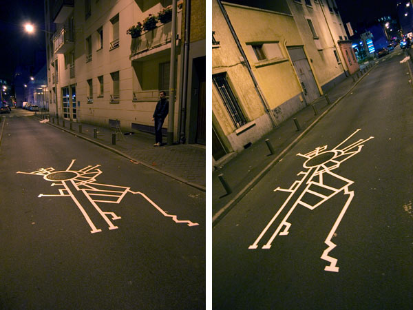
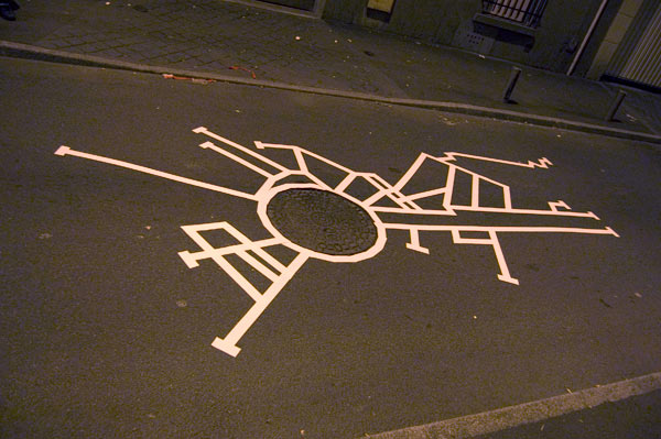
Chaque partie de Paris regorge de secrets enfouis. Je décide d’en mettre un à jour. Le tracé représente le plan des sous-sols communiquant avec la plaque d’égoûts (échelle 1/400ème ).
Les carrés représentent les sorties les plus proches (d’autres bouches d’égoûts). Le lieu est la place d’Italie dont j’ai réussi à me procurer le plan des sous-sols (source IGC).
48,86373°Est, 2,40856°Nord sont les coordonnées GPS exacte de l’emplacement de l’intervention.
«Si l’on arrachait l’épiderme hérissé de maisons qui couvre les entrailles du sol de Paris, les regards seraient épouvantés de cette révélation souterraine,de ces formidables arcanes que n’éclaira jamais le soleil… Nous marchons, nous rions, nous dansons, nous jouons sur un tapis composé d’horribles choses, des choses que ne désigne aucune langue et qui attendront toujours un nom.»
Joseph Méry
«Le sous-sol de Paris, si l’œil pouvait en pénétrer la surface, présenterait l’aspect d’un madrépore colossal. Une éponge n’a guère plus de pertuis et de couloirs que la motte de terre de six lieues de tour sur laquelle repose l’antique grande ville. Sans parler des catacombes, qui sont une cave à part, sans parler de l’inextricable treillis des conduits du gaz, sans compter le vaste système tubulaire de la distribution d’eau vive qui aboutit aux bornes-fontaines, les égouts à eux seuls font sous les deux rives un prodigieux réseau ténébreux ; labyrinthe qui a pour fil sa pente.»
Victor Hugo
48Nord 2Est / Paris Labyrinth Street Installation
“48Nord 2Est” is an in situ urban intervention exploring the hidden geography beneath the streets of Paris. Created during my fourth year at fine arts school, the project forms part of a broader body of research devoted to the idea of the labyrinth and, more specifically, to the way a city can be read as a gigantic labyrinth extending both above and below ground. Rather than producing an imaginary map, this intervention makes visible an existing fragment of the underground network that normally remains inaccessible to the public.
At the time, my artistic research focused on understanding how urban space could be interpreted through its invisible structures. Streets, buildings and public squares are only the visible layer of a much larger system composed of tunnels, galleries, technical infrastructures and forgotten passages. Beneath the familiar city lies another city that most people never perceive.
This fascination with underground Paris also led me to develop PARIS UNDAGROUND 2007, an experimental web application designed to visualise the different underground layers hidden beneath the capital. The project explored the labyrinthine organisation of galleries, infrastructures and networks extending below the streets, proposing another way of reading the city through cartography and digital navigation.
48nord 2est extends that same research into public space.
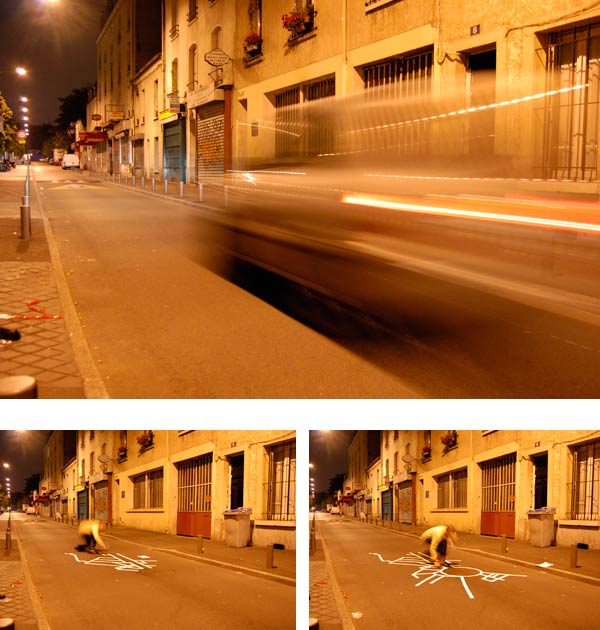
The intervention was carried out directly on a manhole cover located at Place d’Italie. Using adhesive tape, I reproduced the exact plan of the underground galleries connected to that specific sewer access point. Instead of inventing a fictional drawing, the work translates a real technical map into an urban intervention visible to every passer-by.
The plan was established from documentation provided by the Inspection Générale des Carrières (IGC), allowing the underground network to be reproduced at a scale of 1:400. The surrounding squares indicate the nearest neighbouring manholes connected to the same system.
The precise location of the intervention is: 48.86373° N, 2.40856° E
These coordinates identify the exact point where the intervention was installed, linking the visible artwork with the hidden infrastructure beneath it.
The objective was simple: how can we become aware of the immense underground network extending beneath our feet?
Paris contains several hundred kilometres of underground galleries, tunnels and technical infrastructures. Most inhabitants cross these spaces every day without ever imagining their complexity. The intervention attempts to reveal one fragment of this invisible city by projecting its cartography back onto the surface.
Rather than inviting people underground, the project allows the underground to emerge into public space. The drawing becomes a form of translation between two worlds: the hidden labyrinth beneath the pavement and the everyday city experienced above it.
Graphically, the intervention resembles an anonymous map abandoned on the pavement. Without explanation, it appears as a mysterious geometric drawing whose meaning remains deliberately ambiguous. Passers-by encounter an image that clearly follows a logic while offering no immediate key for interpretation.
Only after discovering its origin does the drawing reveal itself as a cartographic representation of the galleries hidden directly below the viewer. What first appears abstract suddenly becomes an operational map describing a real physical space.
In this sense, the work functions simultaneously as a secret revealed and as an instruction manual. It proposes a way of mentally exploring underground Paris without physically entering it. The city becomes readable through layers rather than surfaces, encouraging another perception of urban space.
This relationship between visible and invisible territories has remained a recurring theme throughout my artistic practice. Whether working with abandoned industrial sites, disappearing graffiti, urban mutation or hidden infrastructures, I am interested in revealing the systems that quietly shape the city while remaining largely unnoticed.
The intervention also resonates with literary descriptions of underground Paris, particularly those written by Joseph Méry and Victor Hugo, whose texts vividly evoke the immense hidden labyrinth beneath the capital.
As Joseph Méry wrote:
“If the skin covered with houses were torn away from the entrails of Paris, our eyes would be terrified by this underground revelation… We walk, laugh, dance and play upon a carpet composed of terrible things that no language has ever fully named.”
Similarly, Victor Hugo described the city beneath the city:
“The underground of Paris, if the eye could penetrate its surface, would present the appearance of a colossal madrepore. The sewers alone form beneath both banks a prodigious dark network; a labyrinth whose guiding thread is its slope.”
These literary visions echo the intention behind 48nord 2est. The intervention does not invent a hidden world; it simply makes visible one that has always existed. By transferring a fragment of underground cartography onto the pavement itself, the project invites viewers to reconsider the city as a layered organism whose greatest mysteries often lie directly beneath their feet.
Frequently Asked Questions
What is 48nord 2est?
It is an in situ street installation revealing the underground galleries connected to a Paris manhole through a full-scale cartographic intervention.
How was the map created?
The drawing was reproduced from official underground plans provided by the Inspection Générale des Carrières (IGC) at a scale of 1:400.
What is PARIS UNDAGROUND 2007?
It was an experimental web application I developed to explore and visualise the different underground layers beneath Paris.
Why install the map directly on a manhole?
Placing the map on the exact location connects the visible city with the hidden network beneath it, revealing an invisible urban reality.
How does this project relate to your artistic practice?
It introduces themes that continue throughout my work: urban cartography, hidden infrastructures, labyrinths, invisible cities and the multiple layers that shape our perception of urban space